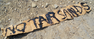
 Reconnecting to the land we fight so hard to protect can be rejuvenating. But when that land is immediately threatened by development of the dirtiest oil on the planet, the experience roots us in the front lines of the struggle. A delegation from PeaceUp, Utah Tar Sands Resistance (also on Facebook) and Living Rivers recently traveled to Eastern Utah to connect to the ecosystems that could be lost to the first U.S. tar sands development.
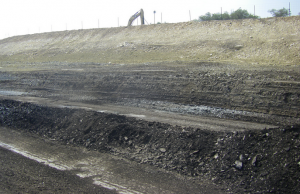 Fourteen people traveled the back roads to the East Tavaputs Plateau. On a particularly high point on the plateau, sits P R Springs—a generous source of crisp, clean ground water. Less than 2 miles away sits the U.S. Oil Sands 2-acre test pit site. Those 2 industrial acres threaten to metastasize like cancer to tens of thousands of acres.
Our band of travelers took two different routes south from US Hwy. 40, each route painting a different picture of oil and gas development in the Uintah Basin.
Willow Creek Canyon, named for a year-round water source, features beautiful rock cliffs, lush plant life and Native American-owned ranches. With the exception of drilling pads (concrete slabs of less than an acre with drill machinery), this land and its unique beauty would easily qualify as a National Monument. Though it’s more than 20 miles from U.S. Oil Sands’ test pit, this serene river valley’s precious water runs downstream from the tar sands pit, threatening the entire watershed with toxic chemical discharges and runoff.
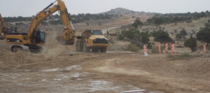 The other route to the U.S. Oil Sands site follows the spine of Seep Ridge as it rises from the Green River near the town of Ouray. What was a dirt roadway through low trees and abundant sage is being widened, flattened and paved to an expanse that could easily accommodate 4 lanes of traffic. This new paved super road will be immeasurably useful to the oil and gas drilling companies operating all along the length of the roadway, including the U.S. Oil Sands site near P R Springs just across the Grand County line.
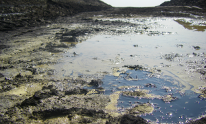 The P R Springs test pit, for now, is about the size of a football field with exposed tar sands glistening like an aging asphalt roadbed. The top tar sands layer is about two dozen feet beneath the surface, with another layer about 75 feet below that. From a distance, one might think they were seeing a coal bed. But the reality is a reeking sludge tar sand that, in the heat of the day, softens and pools and reeks.
We explored another tar sands pit nearby that was abandoned 30 years ago. Yes, that’s right. Tar sands extraction has been tried before on Seep Ridge.
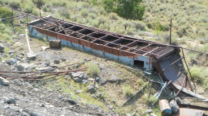 In 1983, the Leonard Murphy Mine began extraction using the same technology available today: solvents. That mine, only slightly larger than U.S. Oil Sands operating test pit, went bust and their giant steel machinery was left to molder on our public lands, sitting on the exposed tar pit that never was restored, an industrial wasteland that still threatens the surrounding life.
The Utah Division of Oil, Gas and Mining uses the Leonard-Murphy Mine moniker also for the contemporary U.S. Oil Sands test pit. The shared name foreshadows one potential fate for this land—scorched, foul, dusty, hot and dead. The staggering destruction that would result from the huge ambitions of U.S. Oil Sands can only really be understood by immersing oneself in web of life that is threatened with erasure.
 Both the old and new Leonard Murphy tar sands pits rest at the top of Main Canyon, so named perhaps because it is a long portion of a complex watershed that connects to Willow Creek Canyon and eventually the Green and Colorado Rivers. Toxic discharge and polluted rainwater-runoff—in test-site proportions—already flow from U.S. Oil Sands through the canyons that now burst with plant and animal life.
In Main Canyon, high-altitude sagebrush at 8,000 feet of elevation gives way to quaking aspen groves, which themselves naturally blend into dense forests of fir and spruce.
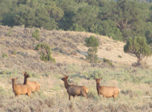 Moreover, this is truly Utah’s Serengeti, one of the last frontiers that still features not just large animals, but abundant animal herds. Gangs of elk find sufficient refuge to support their community. Here, deer still mob with one another for safety. Even wild turkey stick together as they peck and pluck the earth for their nutrition. Soaring over Main Canyon are sometimes five or six raptors of various kinds, including golden eagles. Owls dominate the night sky while coyotes rule the moon shadows. This is a place where squirrels and chipmunks’ skittish natures are not yet tainted by frequent raids on human garbage.
The tar sands test pit—which stands as a black and barren, poisonous 2-acre pock in the middle of all this—still doesn’t represent just how destructive U.S. Oil Sands would be to Main Canyon. It will get bigger, but also more profoundly destructive, threatening to change not just the geology and surface of Main Canyon, but even its contours and topography. “They’re taking the best and easiest stuff now and they’ll save the toughest, cruddiest crap for last,” says Living Rivers’ John Weisheit.
Pray for the gangs of elk; over 2,500 acres of this lush and beautiful land are currently leased for immediate tar sands development by Utah’s State Institutional Trust Land’s Administration, or SITLA. Industry insiders see millions of acres across the Rocky Mountain West as open to tar sands and oil shale development.
U.S. Oil Sands will destroy glorious Main Canyon and more—for a mere 6 hours of national oil consumption.
Six hours pass so fast, but while the profits are hoarded and problems are shared widely, criminals of capitalism and destruction run off with major money. The deep irony here is this destruction of the earth is sold to the public as a fundraiser for schools and children’s futures. But certainly the silent investors who recently gave U.S. Oil Sands $10 million for development are happy to give Utah schools a pitiful haircut of the proceeds while criminals of capitalism and destruction enjoy weekends in the Cayman Islands next to the banks that help them dodge taxes.
Strange as it may seem, those investors are surely victims in this as well. They’re victims of a scam perpetrated by the shady fraud artists at U.S. Oil Sands and the Utah State Legislature. Without severe manipulations, lies, and theft, tar sands in Utah cannot be profitable for a number of logistical reasons.
Reason one: water. While there is water in abundance for gangs of elk and their friends, an industrial tar sands installation would require far more. Willow Creek, a lush year-round oasis, could be sucked dry by U.S. Oil Sands, and still the asphalt-to-oil fraud would thirst for far more.
Reason two: cold. At about 8,000 feet in elevation, the P R Springs test pit site chills to a bitter cold for much of the year. In order for tar sands to be pliable, they need to be very hot. Extracting tar sands will require burning tremendous amounts of other fossil fuels.
Water and cold are two primary reasons oil sands failed in 1983. They will be the reasons it fails again.
Ambivalence is dangerous, however. Overall failure may still create profit opportunities for parasites. U.S. Oil Sands may tear tremendous scars into the earth, perhaps with infusions of taxpayer-subsidies or cash infusions from speculators in the 1%.
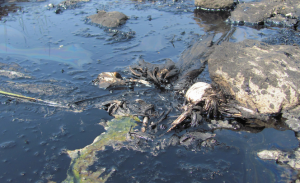 We have already seen one tar sands mining project in Utah scrape the land, pollute it, and leave their junk for someone else to clean up. At the old Lawrence Murphy mine site, there is still a pool of exposed tar, mingling with spring water bubbling to the surface, in which a bird was trapped then died and became just skeleton and feathers – still bogged down in the black goo along with smaller creatures doomed to the same fate.
Defend Main Canyon. Save the Earth. Stop Tar Sands.
Here’s where you come in. Join us on a future trip to P R Springs! The next planned trip is being organized by UT Tar Sands Resistance for October 12-15th. Find the Facebook event here. If you don’t have camping equipment, don’t worry, we’ll provide you with some. We sure that you’ll find – as we did – that connecting to the land that is under threat is the best way to root us in the front lines of the struggle against injustice. We’re making our plans for other future trips, so stay tuned. Join our action e-mail list to receive updates. Like us on Facebook. Follow us on Twitter. Most of all, thank you!
Leave a Reply to Anonymous Cancel reply